![]() rowmaps
rowmaps
these web pages
are being produced by
Barry Cornelius

home
maps
preferences
original data
missing data
KMLs
GPXs
CSVs
GeoJSONs
using Organic Maps
app on a phone
and getting it to
display rights of way
tweets
blog
contact
privacy
Problem with the bridleway North of Lambourn Corner
A map is shown below. The underlying map is an Ordnance Survey 1:25000 map that has been produced by Bing. On the underlying map, public rights of way (PROW) are indicated by green lines. Yellow, blue, plum and red lines have been superimposed on top of the underlying map (and will usually hide these green lines). A yellow line signifies a footpath, a blue line signfies a bridleway, a plum line signifies a restricted byway and a red line signifies a byway open to all traffic (BOAT). I'm sorry that these colours are different from those used elsewhere on this website. You can click on a line to get more details about that PROW. You can click on the + and - buttons to zoom in/out. These superimposed lines have been produced from data obtained from the Council of Oxfordshire (ON) and from the Council of West Berkshire (WB). A dash-dotted line (with the label "UA Bdy") runs from the bottom left to the top right and this indicates the boundary between Oxfordshire (which lies to the West) and West Berkshire (which lies to the East).
The problem
This web page considers a bridleway that lies close to the boundary of Oxfordshire and West Berkshire. Lambourn Corner (which is on the B4000) is shown at the bottom of the map. South of Lambourn Corner, the bridleway (shown in blue) is WB/LAMB/59/1. After crossing the B4000 (at SU289809), it becomes WB/LAMB/59/2. At SU290811, it meets two bridleways: ON/112/26/10/ coming in from the West and WB/LAMB/58/1 coming in from the East. North of this junction it becomes WB/LAMB/59/3. At SU294822, it meets footpath WB/LAMB/74/1 (shown in yellow) and North of this junction the bridleway becomes WB/LAMB/59/4. At SU297825, it meets two bridleways: ON/174/9/10 comes in from the West and WB/LAMB/67/1 comes in from the East. North of this junction it becomes WB/LAMB/59/5 and then it crosses the boundary and becomes ON/174/14/20.
When I visited this area in March 2014, there was no evidence of any use of this bridleway North of Lambourn Corner and there were fences in the way to stop it being used. Instead, judging by the crisp packets, boot prints, hoof prints and horse manure, people were using the dirt track (that is mainly to the West of the bridleway) and that is not a PROW.
show this map on www.rowmaps.com
Below there are several maps from Google Maps.
Superimposed onto these maps
is an
orange line that shows the boundary between Oxfordshire (to the West)
and West Berkshire (to the East).
The data used to produce this line comes from Ordnance Survey's
Boundary-Line product.
So, the following map gives another overview of the area North of Lambourn Corner:

Does anyone use bridleway WB/LAMB/59?
The following photos are meant to demonstrate that in March 2014 I found no evidence of any use of the bridleway North of Lambourn Corner and there were fences in the way to stop it being used.
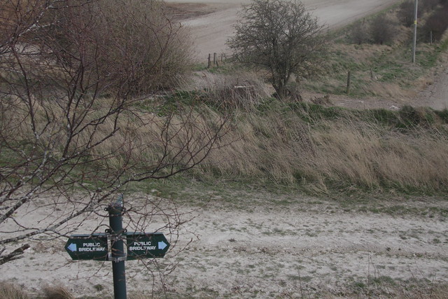
Bridleway WB/LAMB/59/2
runs in a NNE direction from Lambourn Corner (SU289810)
which means it runs to the right of the hedge that is behind the waymark sign
(that is shown in the photo below).
The dirt track is on the left of this hedge.
At SU290811, it meets two bridleways: ON/112/26/10/ coming in from the West and WB/LAMB/58/1 coming in from the East.
The photo below shows the view looking Southwards, back towards Lambourn Corner.
The route of bridleway WB/LAMB/59/2 is from this point down the side of the field to the road that is in the distance.

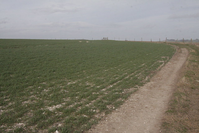
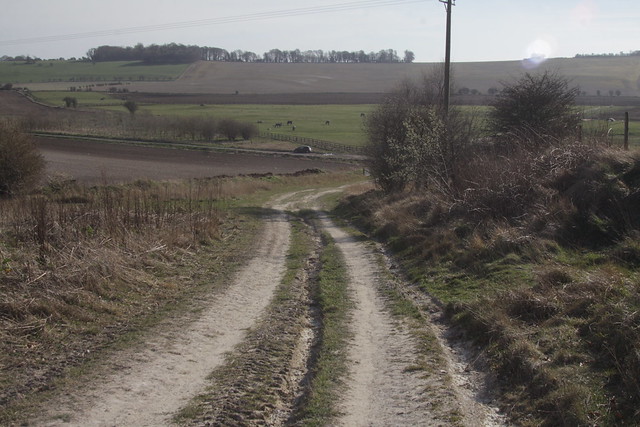
The photo below shows the view looking Northwards from this junction.
Bridleway WB/LAMB/59/3 takes a line up this field that is to the right of the hedge that is on the left.

At SU292818, bridleway WB/LAMB/59/3 crosses the dirt track.
It's not obvious on the ground as to where this happens.
So the photo below shows the view from the dirt track looking South in the general area of the crossing point.
The fence is a few strands of barb wire which are broken in places.

And the photo below shows the view from the same point on the dirt track looking Northwards.
Bridleway WB/LAMB/59 takes a route across the field roughly from here towards the wooden structure in the far distance.
At SU2931582030, bridleway WB/LAMB/59/3 re-crosses the dirt track.
Again, it's not obvious on the ground as to where this happens.
It could be at the wooden structure shown in the photo below.
The route of the bridleway is then roughly from the wooden structure
towards the top centre of the photo where it descends into the valley below.

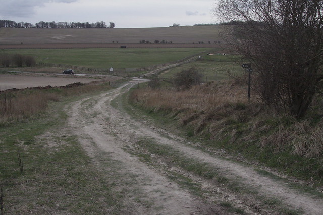
The photo below shows a point that is further North.
On the left you can see the dirt track.
Bridleway WB/LAMB/59 proceeds Northwards roughly from the bottom right of the photo
towards the left hand end of the woodland that is in the middle right of the photo.

So apart from some waypoint signs in the South, there is indication on the ground that there is a bridleway. There is no sign of a path, no foot prints, no hoof prints and there are fences in the way.
Suggestion A: A radical suggestion
The radical suggestion is for bridleway WB/LAMB/59 to be realigned to the route of the dirt track. Some of the existing PROWs would have to be extended to meet the dirt track.
Suggestion B: Fixing the issues
B1: Junction with WB/LAMB/58/1 and ON/112/26/10
On this map, the road that
crosses diagonally from the top left to the bottom middle
is the B4000 (between Ashbury and Lambourn).
The point (at the bottom middle of the map)
where the B4000 meets
the Oxfordshire-West Berkshire boundary (shown in orange)
and bridleway WB/LAMB/59 (shown in blue) is "Lambourn Corner".

show this map on www.rowmaps.com
At the top of this map, there is a meeting of PROWs.
WB/LAMB/59 switches from WB/LAMB/59/2 to WB/LAMB/59/3
and it meets two other bridleways:
WB/LAMB/58/1 comes in from the East and
ON/112/26/10 comes in from the West.
Problem B1A: Big gap between WB/LAMB/58/1 and ON/112/26/10
The West Berkshire data has a T-junction involving WB/LAMB/59/2, WB/LAMB/59/3 and WB/LAMB/58/1. There's a fairly big gap between this T-junction and ON/112/26/10. I think the T-junction is at 51.52813,-1.58328 and ON/112/26/10 ends at 51.52821,-1.58344. I think that's 14 metres.
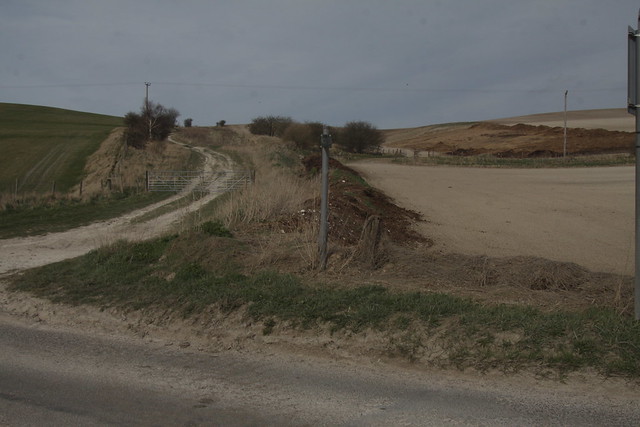
Problem B1B: Waymark sign is in the wrong place
On the Western sign of the dirt track there is a waymark sign. It has three arrows so it indicates a T-junction rather than a "crossroads". Two of the arrows point up and down the dirt track (where there is no public right of way) and third arrow points in the direction of WB/LAMB/58/1. But because this waymark sign is besides the dirt track, it is in the wrong place.
The photo shown below is looking Southwards down the dirt track.
The waymark sign is on the right of this photo.
The photo shown below is looking Eastwards from behind the waymark sign.
The real crossroads of the paths is at the top middle of this photo.
That is where this waymark sign ought to be.
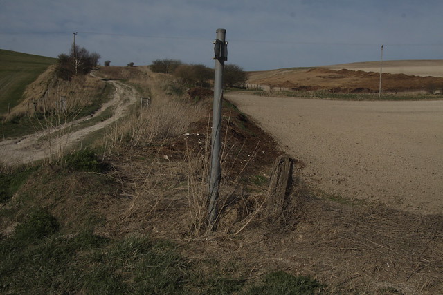
Problem B1C: The junction is staggered
The map above which is produced from the data of the two councils implies a crossroads whereas, on the ground, the junction is staggered. ON/112/26/10 arrives at the dirt track further to the North than what is indicated on the map.
The photo of the Eastern end of ON/112/26/10 shown below was taken from the dirt track.

The photo shown below was taken from roughly the same point but looking Southwards
down the dirt track.
The route to the West Berkshire paths is to the left but it is further down the dirt track.
Hence the junction is staggered.
And there is a big gap between the end of ON/112/26/10 and the junction of
WB/LAMB/59/2, WB/LAMB/59/3
and WB/LAMB/58/1.
Problem B2: The two crossings of the dirt track by WB/LAMB/59/3
Reminder: the orange line shows the boundary between Oxfordshire and West Berkshire.
The blue line shows bridleway WB/LAMB/59/3 twice crossing the dirt track. There should be waymark signs indicating where this happens
and stiles should be inserted over the fences (which were shown in the earlier photos):

show this map on www.rowmaps.com
Problem B3: Gap between footpath ON/112/35/10 and footpath WB/LAMB/74/1
The yellow line on the left shows footpath ON/112/35/10
and the yellow line on the right shows WB/LAMB/74/1.
There's a gap between the ends of these footpaths. This occurs at about SU292822/SU293822.

show this map on www.rowmaps.com
Problem B4: Gap between ON/174/9/10 and WB/LAMB/67/1
There's a gap betweens the end of
bridleway ON/174/9/10 (shown on the bottom left)
and the junction of
bridleways WB/LAMB/59/4,
WB/LAMB/59/5
and
WB/LAMB/67/1 (shown on the bottom right).
I don't think the fence alongside the dirt road permits access to
WB/LAMB/67/1.

show this map on www.rowmaps.com
Problem B5: Misalignment of ON/174/14/20 and WB/LAMB/59/5
There's a misalignment between
bridleway ON/174/14/20 (shown on the top left)
and
WB/LAMB/59/5 (shown going through the woodland on the right).
Note that this map implies that the West Berkshire data has
WB/LAMB/59/5 going through the wood.
And I don't think the fence alongside the dirt road permits access to
WB/LAMB/59/5.
show this map on www.rowmaps.com